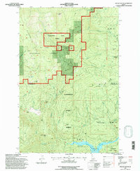
1994 Map of Pinchot Butte
USGS Topo · Published 1997About this map
St Joe National Forest and Floodwood State Forest dominate this high-altitude landscape along the border of Shoshone and Clearwater counties. The map captures a backcountry interior defined by timber management and remote outposts, including the CPTPA Headquarters and several isolated camps such as Diamond Floodwood Camp and Last Inch Camp. In the south, the Dworshak Reservoir fills the valley of the Little North Fork Clearwater River, reflecting the significant topographical changes brought by mid-century dam projects. Cultural sites like the Mary Mix Cabin (Site) and names such as Deadman Point and Bear Wallow hint at a history of early settlers and hunters who moved through these steep ridges and narrow creek drainages long before the modern trail network was established.
Find a feature on this map
56 named features on this map. Tap any name to fly to it.
Don’t see what you’re looking for? This feature index may not catch every label — zoom into the map to look around manually.
Map Details
Editions of this 1994 Pinchot Butte Map
This is the sole edition of this map. No revisions or reprints were ever made.
Other maps of this area

1914 · Avery
USGS Topo · 1:125,000

1917 · Avery
USGS Topo · 1:125,000

1923 · Washington Creek
USGS Topo · 1:125,000

1936 · Boehls Butte
USGS Topo · 1:48,000

1943 · Boehls Butte
USGS Topo · 1:62,500

1955 · Pullman
USGS Topo · 1:250,000

1955 · Spokane
USGS Topo · 1:250,000

1956 · Wallace
USGS Topo · 1:250,000

1956 · Hamilton
USGS Topo · 1:250,000

1958 · Spokane
USGS Topo · 1:250,000