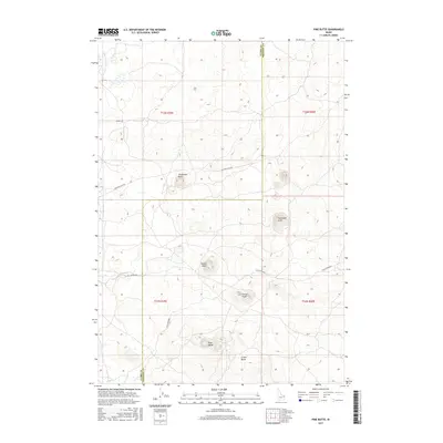
2017 Map of Pine Butte
USGS Topo · Published 2017About this map
The volcanic landscape of the Idaho high desert is defined by a series of distinct elevations including Pine Butte and Crater Butte. This survey, crossing the border of Clark and Fremont Counties, reveals a terrain shaped by geology and livestock movement. The presence of the Stock Driveway in the southern portion of the map highlights the area's continued importance for local ranching and seasonal animal migrations. Roads such as Eighteen Mile Rd and Split Butte Rd navigate the low-lying areas between prominent landmarks like Threemile Knoll, Twitchells Knoll, and Blacks Knoll. This 2017 edition documents the persistent land-use patterns in a region where volcanic knolls serve as the primary navigational markers across the high plains.
Find a feature on this map
15 named features on this map. Tap any name to fly to it.
Don’t see what you’re looking for? This feature index may not catch every label — zoom into the map to look around manually.
Map Details
Editions of this 2017 Pine Butte Map
This is the sole edition of this map. No revisions or reprints were ever made.
Other maps of this area

1955 · Ashton
USGS Topo · 1:250,000

1958 · Ashton
USGS Topo · 1:250,000

1960 · Ashton
USGS Topo · 1:250,000
1965 · Split Butte
USGS Topo · 1:24,000

1965 · Crystal Butte
USGS Topo · 1:24,000

1965 · Sheridan Reservoir
USGS Topo · 1:24,000

1972 · Pine Butte
USGS Topo · 1:24,000
1972 · Split Rock
USGS Topo · 1:24,000

1972 · Antelope Valley
USGS Topo · 1:24,000

1972 · Kilgore
USGS Topo · 1:24,000