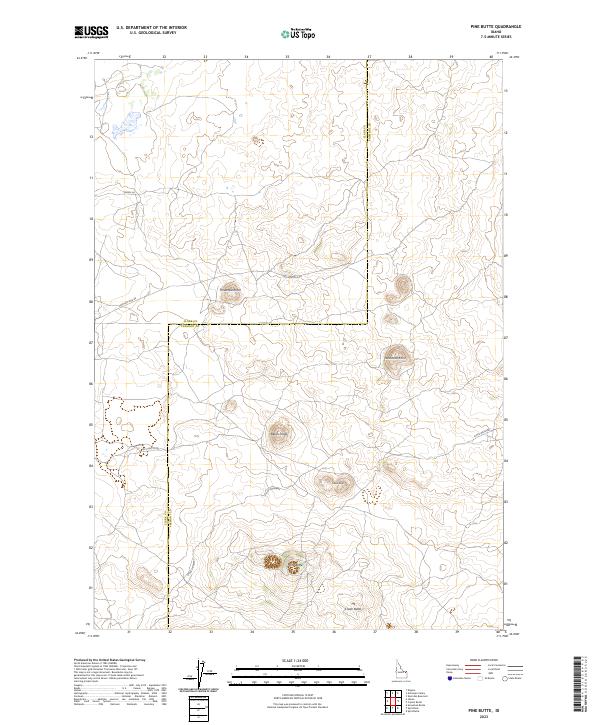
2023 Map of Pine Butte
USGS Topo · Published 2023About this map
The volcanic landscape of the Idaho high desert is defined by prominent rises like Pine Butte and Crater Butte in this contemporary topographical survey. Located along the boundary of Clark and Fremont Counties, the area is crisscrossed by specialized routes such as the Stock Driveway, indicating a land use historically tied to livestock movement across the arid plateau. Several named elevations, including Blacks Knoll and Twitchells Knoll, serve as primary landmarks in a region largely devoid of permanent settlements. Local access is provided by unpaved thoroughfares like Eighteen Mile Rd and Split Butte Rd, which connect the isolated knolls. The map preserves the specific placement of individual ranch-style roads like Jensen Ln, providing a detailed record of modern land management and navigation in this corner of the Snake River Plain.
Find a feature on this map
15 named features on this map. Tap any name to fly to it.
Don’t see what you’re looking for? This feature index may not catch every label — zoom into the map to look around manually.
Map Details
Editions of this 2023 Pine Butte Map
This is the sole edition of this map. No revisions or reprints were ever made.
Other maps of this area

1955 · Ashton
USGS Topo · 1:250,000

1958 · Ashton
USGS Topo · 1:250,000

1960 · Ashton
USGS Topo · 1:250,000
1965 · Split Butte
USGS Topo · 1:24,000

1965 · Crystal Butte
USGS Topo · 1:24,000

1965 · Sheridan Reservoir
USGS Topo · 1:24,000

1972 · Pine Butte
USGS Topo · 1:24,000
1972 · Split Rock
USGS Topo · 1:24,000

1972 · Antelope Valley
USGS Topo · 1:24,000

1972 · Kilgore
USGS Topo · 1:24,000