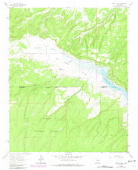
1963 Map of Pine Canyon
USGS Topo · Published 1981About this map
Las Tuces Valley dominates this high-altitude landscape where the McKinley and Cibola county lines meet within the Cibola National Forest. The map documents a transition in land use, showing the spread of the Bluewater Lake shoreline alongside established cattle operations like Stallings Ranch and Pruitt Ranch. Water sources are vital markers in this arid environment, with the Flowing Well and Cottonwood Gulch Spring providing critical points for early ranchers. The expansion of Bluewater State Park is visible in the southeastern quadrant, reflecting the area's growth as a recreational destination. Traces of seasonal drainages, including Cottonwood Creek and Sawyer Creek, provide a glimpse into the natural water networks that shaped early settlement patterns and the placement of remote homesteads.
Find a feature on this map
13 named features on this map. Tap any name to fly to it.
Don’t see what you’re looking for? This feature index may not catch every label — zoom into the map to look around manually.
Map Details
Editions of this 1963 Pine Canyon Map
2 editions found
Other maps of this area

1886 · Wingate
USGS Topo · 1:250,000

1892 · Wingate
USGS Topo · 1:250,000

1951 · Mt Sedgwick
USGS Topo · 1:24,000

1952 · Post Office Flat
USGS Topo · 1:24,000

1954 · Gallup
USGS Topo · 1:250,000

1958 · Gallup
USGS Topo · 1:250,000

1959 · Gallup
USGS Topo · 1:250,000

1961 · Cottonwood Canyon
USGS Topo · 1:24,000

1962 · Gallup
USGS Topo · 1:250,000

1962 · Continental Divide
USGS Topo · 1:24,000