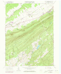
1963 Map of Pine Grove Mills
USGS Topo · Published 1973About this map
The Tussey Mountain ridge dominates this 1960s survey, marking a distinct boundary between the agricultural valleys of Ferguson and the dense woodlands of the Rothrock State Forest. Along the northern edge, the village of Pine Grove Mills sits at the foot of the ridge, while smaller settlements like Baileyville and Rockspring dot the Whitehall Valley. The presence of the Bellefonte Central Railroad and an Old R.R. Grade near Beaver Branch indicates the region's historical transport patterns, linking rural centers to broader markets.
Find a feature on this map
59 named features on this map. Tap any name to fly to it.
Don’t see what you’re looking for? This feature index may not catch every label — zoom into the map to look around manually.
Map Details
Editions of this 1963 Pine Grove Mills Map
4 editions found
Other maps of this area

1908 · Bellefonte
USGS Topo · 1:62,500

1909 · Bellefonte
USGS Topo · 1:62,500

1919 · Menno
USGS Topo · 1:62,500

1922 · Philipsburg
USGS Topo · 1:62,500

1923 · Tyrone
USGS Topo · 1:62,500

1929 · Tyrone
USGS Topo · 1:48,000

1933 · Tyrone
USGS Topo · 1:62,500

1935 · Allensville
USGS Topo · 1:62,500

1938 · Allensville
USGS Topo · 1:62,500

1939 · Philipsburg
USGS Topo · 1:62,500