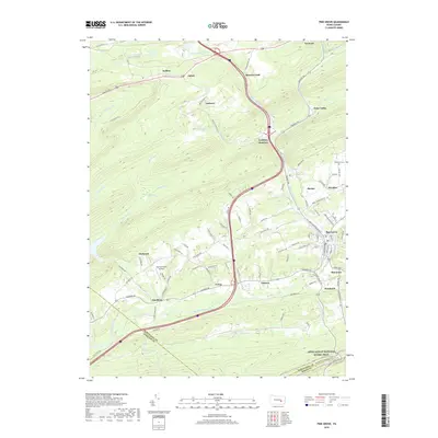
2019 Map of Pine Grove
USGS Topo · Published 2019About this map
Swatara Creek winds through the southern landscape of this 2019 survey, defining a valley corridor that has long served as a primary transportation artery through the coal region of Pennsylvania. The map illustrates a dense network of small settlements and neighborhood clusters such as Pine Grove, Suedberg, and Marstown, which are interspersed with local landmarks like the Fairview Farm Airfield. To the north, the terrain transitions into the steeper ridges of the Appalachian range, where the legacy of industry is visible in the placement of Lorberry Junction and the scattered mountain communities of Joliett and Keffers. Genealogists may find interest in the precise location of Hollerman Cem near Ravine, while the presence of Echo Valley and Paradise reflects the traditional naming patterns of these rural townships. The drainage patterns of Fishing Cr and Rausch Creek underscore the complex hydrology of a region shaped by both its natural geography and its industrial past.
Find a feature on this map
99 named features on this map. Tap any name to fly to it.
Don’t see what you’re looking for? This feature index may not catch every label — zoom into the map to look around manually.
Map Details
Editions of this 2019 Pine Grove Map
This is the sole edition of this map. No revisions or reprints were ever made.
Other maps of this area

1891 · Lebanon
USGS Topo · 1:62,500

1892 · Lykens
USGS Topo · 1:62,500

1892 · Hummelstown
USGS Topo · 1:62,500

1892 · Pine Grove
USGS Topo · 1:62,500

1893 · Lykens
USGS Topo · 1:62,500

1893 · Lebanon
USGS Topo · 1:62,500

1899 · Lebanon
USGS Topo · 1:62,500

1924 · Hummelstown
USGS Topo · 1:62,500

1943 · Lebanon
USGS Topo · 1:62,500

1943 · Lykens
USGS Topo · 1:62,500
Featured Places
- Bethel Township, PA
- Hegins Township, PA
- Pine Grove, Pine Grove Township
- Frailey Township, PA
- Brookside, Pine Grove Township