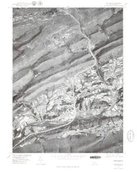
1977 Map of Pine Grove
USGS Topo · Published 1979About this map
Pine Grove and its surrounding ridge-and-valley landscape are documented in this orthophotograph, captured in the late 1970s. The imagery reveals the distinct linear geography of Schuylkill County, where human settlement is concentrated in the narrow corridors between prominent landforms like Second Mountain and Swope Mountain. The winding course of Swatara Creek provides the primary drainage for the area, cutting through the gaps where smaller hamlets such as Ravine and Suedberg are established.
Find a feature on this map
11 named features on this map. Tap any name to fly to it.
Don’t see what you’re looking for? This feature index may not catch every label — zoom into the map to look around manually.
Map Details
Editions of this 1977 Pine Grove Map
This is the sole edition of this map. No revisions or reprints were ever made.
Other maps of this area

1891 · Lebanon
USGS Topo · 1:62,500

1892 · Lykens
USGS Topo · 1:62,500

1892 · Hummelstown
USGS Topo · 1:62,500

1892 · Pine Grove
USGS Topo · 1:62,500

1893 · Lykens
USGS Topo · 1:62,500

1893 · Lebanon
USGS Topo · 1:62,500

1899 · Lebanon
USGS Topo · 1:62,500

1924 · Hummelstown
USGS Topo · 1:62,500

1943 · Lebanon
USGS Topo · 1:62,500

1943 · Lykens
USGS Topo · 1:62,500
Featured Places
- Bethel Township, PA
- Hegins Township, PA
- Pine Grove, Pine Grove Township
- Union Township, PA
- Tremont Township, PA