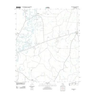
2012 Map of Pine Grove
USGS Topo · Published 2012About this map
The Amite River winds through this section of Saint Helena Parish, defining a landscape of creek bottoms and timberlands in the early 21st century. The settlement of Pine Grove serves as a local hub near the eastern edge, marked by the Pine Grove Lookout Tower, while Grangeville sits to the northwest along the upper reaches of Pigeon Cr. This area is notable for its high density of family and community burial grounds, including Claiborne Cem, Mullens Cem, and Sand Hill Cem, which offer significant value for genealogical research. The road network is a mix of parish routes like Parish Road 77 and established lanes such as Lep Lee Rd, reflecting a rural economy shaped by both agriculture and the legacy of the regional timber industry. The presence of the Overton Private Airport and the youth camp Camp Stallion further illustrate the contemporary land use of this river-fed corridor.
Find a feature on this map
74 named features on this map. Tap any name to fly to it.
Don’t see what you’re looking for? This feature index may not catch every label — zoom into the map to look around manually.
Map Details
Editions of this 2012 Pine Grove Map
This is the sole edition of this map. No revisions or reprints were ever made.
Other maps of this area

1941 · Gilead
USGS Topo · 1:31,680

1942 · Montpelier
USGS Topo · 1:31,680

1942 · Pine Grove
USGS Topo · 1:31,680

1942 · Pride
USGS Topo · 1:31,680

1942 · Gilead
USGS Topo · 1:31,680

1942 · Watson
USGS Topo · 1:31,680

1942 · Satsuma
USGS Topo · 1:31,680

1949 · Bluff Creek
USGS Topo · 1:31,680

1950 · Doyle
USGS Topo · 1:31,680

1950 · Greensburg
USGS Topo · 1:31,680