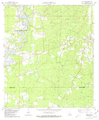
1980 Map of Pine Grove
USGS Topo · Published 1981About this map
The Amite River carves a winding path along the western boundary of this parish landscape, where extraction and agriculture define the local economy. In the late 1970s, extensive Sand And Gravel Pits dotted the terrain near Grangeville, illustrating the area's industrial reliance on river-deposited resources. Further east, the settlement of Pine Grove serves as a local hub, anchored by the Pine Grove Sch and St Joseph Ch.
Find a feature on this map
39 named features on this map. Tap any name to fly to it.
Don’t see what you’re looking for? This feature index may not catch every label — zoom into the map to look around manually.
Map Details
Editions of this 1980 Pine Grove Map
This is the sole edition of this map. No revisions or reprints were ever made.
Other maps of this area

1941 · Gilead
USGS Topo · 1:31,680

1942 · Montpelier
USGS Topo · 1:31,680

1942 · Pine Grove
USGS Topo · 1:31,680

1942 · Pride
USGS Topo · 1:31,680

1942 · Gilead
USGS Topo · 1:31,680

1942 · Watson
USGS Topo · 1:31,680

1942 · Satsuma
USGS Topo · 1:31,680

1949 · Bluff Creek
USGS Topo · 1:31,680

1950 · Doyle
USGS Topo · 1:31,680

1950 · Greensburg
USGS Topo · 1:31,680