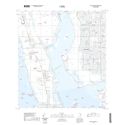
2021 Map of Pine Island Center
USGS Topo · Published 2021About this map
Pine Island and the dense canal-front developments of western Cape Coral dominate this 2021 landscape, illustrating the intense intersection of coastal residential growth and environmental conservation. The map details the intricate waterway networks of the Caloosahatchee River and Matlacha Pass, while highlighting long-standing coastal settlements like St. James City and Pine Island Center. A significant historical and cultural landmark, the Galt Island Burial Mound, is situated near Galt Island, providing a tangible link to the area's ancient inhabitants amidst modern features like the Woodstock Airport. Extensive protected lands are visible through the Charlotte Harbor Preserve State Park Trl, which threads through the mangrove systems and tidal creeks. The presence of the Florida Circumnavigational Paddling Trl and the Great Calusa Blueway Trail Phase III Trl underscores the region's focus on water-based transit and recreation in the early 21st century.
Find a feature on this map
81 named features on this map. Tap any name to fly to it.
Don’t see what you’re looking for? This feature index may not catch every label — zoom into the map to look around manually.
Map Details
Editions of this 2021 Pine Island Center Map
This is the sole edition of this map. No revisions or reprints were ever made.
Other maps of this area

1956 · West Palm Beach
USGS Topo · 1:250,000

1956 · Tampa
USGS Topo · 1:250,000

1956 · Charlotte Harbor
USGS Topo · 1:250,000

1957 · West Palm Beach
USGS Topo · 1:250,000

1958 · West Palm Beach
USGS Topo · 1:250,000

1958 · Matlacha
USGS Topo · 1:24,000

1958 · Captiva
USGS Topo · 1:24,000

1958 · Fort Myers NW
USGS Topo · 1:24,000

1958 · Fort Myers SW
USGS Topo · 1:24,000

1958 · Sanibel
USGS Topo · 1:24,000