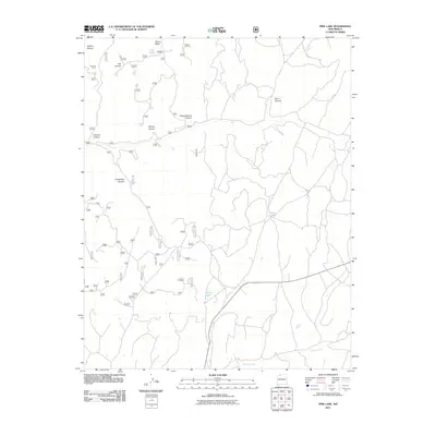
2011 Map of Pine Lake
USGS Topo · Published 2011About this map
Pine Lake and Coyote Lake serve as primary landmarks in this high-altitude landscape of Rio Arriba County, defined by a complex network of seasonal drainages and mesas. This 2011 survey reveals an intricate system of forest roads, such as 314 and 315, that navigate the broken terrain between Chosa Mesa and the surrounding canyons. The land's utility is marked by features like Scissors Corral near the head of Scissor Canyon, indicating the persistent role of ranching in this part of New Mexico. Notable geographic features like Piedra Blanca Canyon and Willow Canyon carve through the sandstone-capped mesa country, while Tapicito Creek winds through the southern reaches of the quadrangle. For those studying the intersection of public land management and traditional land use, the map provides a precise record of access routes into areas like Lost Canyon and Valencia Canyon.
Find a feature on this map
56 named features on this map. Tap any name to fly to it.
Don’t see what you’re looking for? This feature index may not catch every label — zoom into the map to look around manually.
Map Details
Editions of this 2011 Pine Lake Map
This is the sole edition of this map. No revisions or reprints were ever made.
Other maps of this area

1889 · Largo
USGS Topo · 1:250,000

1895 · Largo
USGS Topo · 1:250,000

1954 · Aztec
USGS Topo · 1:250,000

1958 · Aztec
USGS Topo · 1:250,000

1962 · Aztec
USGS Topo · 1:250,000

1963 · Lapis Point
USGS Topo · 1:24,000

1963 · Schmitz Ranch
USGS Topo · 1:24,000

1963 · Gobernador
USGS Topo · 1:24,000
1963 · Ojito
USGS Topo · 1:24,000
1963 · Cement Lake
USGS Topo · 1:24,000