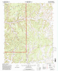
1995 Map of Pine Lake
USGS Topo · Published 1997About this map
Jicarilla Apache Indian Reservation lands meet the Carson National Forest in this high-desert landscape of Rio Arriba County. The terrain is defined by massive plateau formations like Chosa Mesa and Cereza Mesa, deeply incised by a network of drainages including Carrizo Canyon and Arroyo Companero. While the land appears arid, it is dotted with critical water sources for livestock and wildlife, from the eponymous Pine Lake to isolated points like Valencia Spring, Coyote Springs, and Iron Spring.
Find a feature on this map
47 named features on this map. Tap any name to fly to it.
Don’t see what you’re looking for? This feature index may not catch every label — zoom into the map to look around manually.
Map Details
Editions of this 1995 Pine Lake Map
This is the sole edition of this map. No revisions or reprints were ever made.
Other maps of this area

1889 · Largo
USGS Topo · 1:250,000

1895 · Largo
USGS Topo · 1:250,000

1954 · Aztec
USGS Topo · 1:250,000

1958 · Aztec
USGS Topo · 1:250,000

1962 · Aztec
USGS Topo · 1:250,000

1963 · Lapis Point
USGS Topo · 1:24,000

1963 · Schmitz Ranch
USGS Topo · 1:24,000

1963 · Gobernador
USGS Topo · 1:24,000
1963 · Ojito
USGS Topo · 1:24,000
1963 · Cement Lake
USGS Topo · 1:24,000