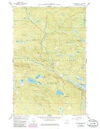
1959 Map of Pine Mountain
USGS Topo · Published 1986About this map
The Brule River winds through the heart of this Northwoods landscape, which was documented during the late 1950s and updated with mid-1980s data. This terrain is defined by a dense network of glacial lakes and waterways, including Northern Light Lake, Musquash Lake, and the remote Assinika Lake. Connectivity is provided by the iconic Gunflint Trail, which serves as the primary artery through the Superior National Forest. For local history and genealogy, the map identifies the Gunflint Camp (Site) and a Lookout Tower positioned atop Pine Mountain, overlooking the vast Brule River State Forest. The presence of a Gravel Pit and scattered logging activity, evidenced by labels like Woodpile and Logger Lake, highlights the era's reliance on forest resources and seasonal transit in northeastern Minnesota.
Find a feature on this map
37 named features on this map. Tap any name to fly to it.
Don’t see what you’re looking for? This feature index may not catch every label — zoom into the map to look around manually.
Map Details
Editions of this 1959 Pine Mountain Map
3 editions found
Other maps of this area

1954 · Two Harbors
USGS Topo · 1:250,000

1957 · Two Harbors
USGS Topo · 1:250,000

1957 · Quetico
USGS Topo · 1:250,000

1958 · Two Harbors
USGS Topo · 1:250,000

1959 · Northern Light Lake
USGS Topo · 1:24,000

1959 · Pine Mountain
USGS Topo · 1:24,000

1959 · Lima Mountain
USGS Topo · 1:24,000

1959 · Hungry Jack Lake
USGS Topo · 1:24,000

1959 · Pine Lake West
USGS Topo · 1:24,000

1959 · Crocodile Lake
USGS Topo · 1:24,000