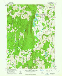
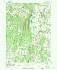
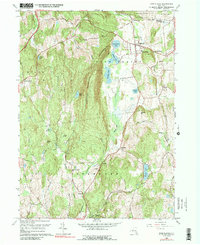
1960 Map of Pine Plains
USGS Topo · Published 1963This historical map portrays the area of Pine Plains in 1960, primarily covering Dutchess County as well as portions of Columbia County. Featuring a scale of 1:24000, this map provides a highly detailed snapshot of the terrain, roads, buildings, counties, and historical landmarks in the Pine Plains region at the time. Published in 1963, it is one of 4 known editions of this map due to revisions or reprints.
Find a feature on this map
53 named features on this map. Tap any name to fly to it.
Don’t see what you’re looking for? This feature index may not catch every label — zoom into the map to look around manually.
Map Details
Editions of this 1960 Pine Plains Map
4 editions found
Historical Maps of Pachin Mills Through Time
24 maps found

1893 Clove
Dutchess County, NY

1894 Clove
Dutchess County, NY

1898 Clove
Dutchess County, NY

1898 Rhinebeck
Dutchess County, NY

1901 Clove
Dutchess County, NY

1934 Rhinebeck
Dutchess County, NY

1939 Rhinebeck
Dutchess County, NY

1945 Pawling
Dutchess County, NY

1946 Verbank
Dutchess County, NY

1947 Pawling
Dutchess County, NY

1947 Wappinger Falls
Dutchess County, NY

1948 Pine Plains
Dutchess County, NY

1948 Poughquag
Dutchess County, NY

1957 Pleasant Valley
Dutchess County, NY

1958 Amenia
Dutchess County, NY

1958 Pawling
Dutchess County, NY

1960 Pine Plains
Dutchess County, NY

1960 Poughquag
Dutchess County, NY

1960 Verbank
Dutchess County, NY

1963 Hyde Park
Dutchess County, NY

1963 Kingston East
Dutchess County, NY

1963 Rock City
Dutchess County, NY

1980 Hyde Park
Dutchess County, NY

1998 Pawling
Dutchess County, NY