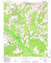
1948 Map of Pinebluff
USGS Topo · Published 1982About this map
Pinebluff and the surrounding Moore County landscape are defined by a mix of agricultural heritage and large-scale military and conservation holdings. The Seaboard Coast Line railroad anchors the northern settlements, passing through Addor and alongside a specialized Ice Loading Platform, which likely served the region's agricultural shipments. To the south and west, the landscape transitions into extensive state and federal tracts, including the Sandhills Game Land and the Camp Mackall Military Reservation.
Find a feature on this map
35 named features on this map. Tap any name to fly to it.
Don’t see what you’re looking for? This feature index may not catch every label — zoom into the map to look around manually.
Map Details
Editions of this 1948 Pinebluff Map
3 editions found
Other maps of this area

1942 · Troy
USGS Topo · 1:125,000

1942 · Rockingham
USGS Topo · 1:125,000

1948 · Southern Pines
USGS Topo · 1:62,500

1948 · Pinebluff
USGS Topo · 1:24,000

1948 · Mc Cain
USGS Topo · 1:24,000

1949 · Wagram
USGS Topo · 1:24,000

1949 · Silver Hill
USGS Topo · 1:24,000

1949 · West End
USGS Topo · 1:24,000

1949 · Hoffman
USGS Topo · 1:24,000

1949 · Marston
USGS Topo · 1:24,000