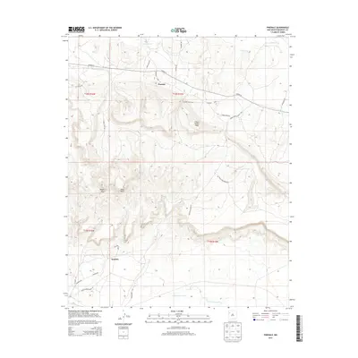
2013 Map of Pinedale
USGS Topo · Published 2013About this map
Pinedale sits at the junction of several historic transport paths including Lord Valley Rd and Co Road 15, marking a transition between the northern valley floor and the elevated formations to the south. The landscape is defined by massive geographic features like Midget Mesa and the prominent Fallen Timber Ridge, which stretch across the central terrain. Water sources, vital in this arid environment, are documented by the Puerco River and the seasonal S Fork Puerco River, along with isolated points like Tumbity Spring. To the southwest, the settlement of Iyanbito is positioned near Indian Service Route 43, reflecting the organized network of service roads and rural routes such as Sunnyside Ranch Rd that connect these high-desert communities. The map highlights the complex relationship between the natural topography of Mesa Butte and the evolving infrastructure of the Eastern Navajo Agency.
Find a feature on this map
30 named features on this map. Tap any name to fly to it.
Don’t see what you’re looking for? This feature index may not catch every label — zoom into the map to look around manually.
Map Details
Editions of this 2013 Pinedale Map
This is the sole edition of this map. No revisions or reprints were ever made.
Other maps of this area

1886 · Wingate
USGS Topo · 1:250,000

1892 · Wingate
USGS Topo · 1:250,000

1954 · Gallup
USGS Topo · 1:250,000

1958 · Gallup
USGS Topo · 1:250,000

1959 · Gallup
USGS Topo · 1:250,000

1962 · Gallup
USGS Topo · 1:250,000

1962 · Ciniza
USGS Topo · 1:24,000

1962 · Continental Divide
USGS Topo · 1:24,000
1963 · Mariano Lake
USGS Topo · 1:24,000
1963 · Pinedale
USGS Topo · 1:24,000
Featured Places
- Eastern Navajo Agency, NM
- Pinedale, Eastern Navajo Agency
- Iyanbito, Eastern Navajo Agency
- McKinley County, NM
- United States