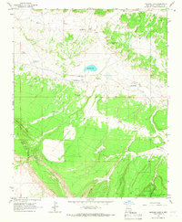
1963 Map of Mariano Lake
USGS Topo · Published 1967About this map
Mariano Lake serves as a central landmark in this high-desert landscape of McKinley County, where the high plateau of northwestern New Mexico meets the southern reaches of the Cibola National Forest. The 1963 field survey documents a community defined by its water sources and mission outposts, including the Holiness Indian Mission and the Berean Mission near the eponymous lake. To the north, the Puerco River carves through the terrain, while landmarks like Standing Rock and Fallen Timber Ridge provide navigational anchors for local travelers.
Find a feature on this map
23 named features on this map. Tap any name to fly to it.
Don’t see what you’re looking for? This feature index may not catch every label — zoom into the map to look around manually.
Map Details
Editions of this 1963 Mariano Lake Map
2 editions found
Other maps of this area

1886 · Wingate
USGS Topo · 1:250,000

1892 · Wingate
USGS Topo · 1:250,000

1954 · Gallup
USGS Topo · 1:250,000

1958 · Gallup
USGS Topo · 1:250,000

1959 · Gallup
USGS Topo · 1:250,000

1962 · Gallup
USGS Topo · 1:250,000

1962 · Ciniza
USGS Topo · 1:24,000

1962 · Continental Divide
USGS Topo · 1:24,000
1963 · Hosta Butte
USGS Topo · 1:24,000
1963 · Crownpoint
USGS Topo · 1:24,000
Featured Places
- Eastern Navajo Agency, NM
- Mariano Lake, Eastern Navajo Agency
- McKinley County, NM
- United States
- New Mexico