2023 Map of Pinedale
USGS Topo · Published 2023About this map
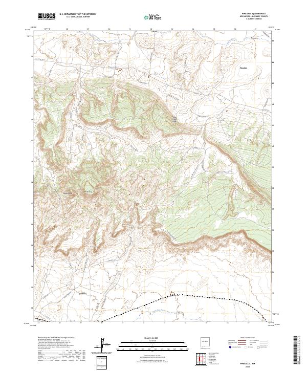
Pinedale and Iyanbito anchor this high-desert landscape in McKinley County, where the drainages of the Puerco River and the South Fork Puerco River define the local topography. The map reveals a network of roads that service the high plateaus and valleys, including Burnt Corn Rd, Sweet Water Rd, and the Sunnyside Ranch Rd. Significant elevation changes are marked by prominent geological features such as Midget Mesa, Mesa Butte, and Fallen Timber Ridge. The presence of Tumbila Spring highlights the critical importance of water sources in this arid region. The surveyor's grid is overlaid across a mix of valley floors and steep ridges, showing a modern spatial organization that respects the complex natural terrain while providing access via routes like Navajo Svc Rte 11 and the Pinedale Loop.
Find a feature on this map
36 named features on this map. Tap any name to fly to it.
Don’t see what you’re looking for? This feature index may not catch every label — zoom into the map to look around manually.
Map Details
Editions of this 2023 Pinedale Map
This is the sole edition of this map. No revisions or reprints were ever made.
Historical Maps of Pinedale Through Time
Featured Locations
- United States
- Eastern Navajo Agency, NM
- McKinley County, NM
- Pinedale, Eastern Navajo Agency
- Iyanbito, Eastern Navajo Agency