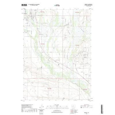
2017 Map of Pinedale
USGS Topo · Published 2017About this map
Pinedale serves as the gateway to the high desert and mountains of western Wyoming in this 2017 survey. The town grid is clearly defined by historic thoroughfares like Mill St and Charles St, while the Pinedale Cem sits on the northern edge near Pine Cr. To the south, the landscape opens into broad alluvial plains and sagebrush-covered hills, marked by prominent geological features including Ruby Hill, The Mesa, and the distinctive Two Buttes. The movement of water through this arid region is critical, evidenced by the winding path of the New Fork River, the Desert Reservoir Number 3, and local drainages like Pole Cr. Transport infrastructure, essential for ranching and remote logistics, is documented through routes such as Fayette Pole Creek Rd and the proximity of aviation services at Ralph Wenz Field. This map provides a detailed view of the infrastructure supporting a modern Wyoming community rooted in a vast natural environment.
Find a feature on this map
102 named features on this map. Tap any name to fly to it.
Don’t see what you’re looking for? This feature index may not catch every label — zoom into the map to look around manually.
Map Details
Editions of this 2017 Pinedale Map
This is the sole edition of this map. No revisions or reprints were ever made.
Other maps of this area

1955 · Lander
USGS Topo · 1:250,000

1958 · Lander
USGS Topo · 1:250,000

1961 · Lander
USGS Topo · 1:250,000

1964 · Two Buttes Reservoir
USGS Topo · 1:24,000

1964 · Boulder Lake
USGS Topo · 1:24,000

1964 · Mount Airy
USGS Topo · 1:24,000

1964 · Mesa Spring
USGS Topo · 1:24,000
1964 · Cora
USGS Topo · 1:24,000

1964 · Boulder
USGS Topo · 1:24,000
1964 · Pinedale
USGS Topo · 1:24,000