
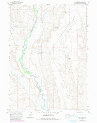
1964 Map of Mesa Spring
USGS Topo · Published 1968About this map
The Green River carves a winding path through the heart of this mid-1960s landscape, flanked by an extensive network of irrigation infrastructure including the Luman Ditch, Hill Ditch, and Harman Ditch. This intricate system of ditches and canals highlights the essential role of water management in the ranching operations and arid environment of Sublette County. On the high ground to the east, The Mesa overlooks the river valley, while the Soap Hole Basin marks the western topography.
Find a feature on this map
14 named features on this map. Tap any name to fly to it.
Don’t see what you’re looking for? This feature index may not catch every label — zoom into the map to look around manually.
Map Details
Editions of this 1964 Mesa Spring Map
2 editions found
Other maps of this area

1939 · Big Piney
USGS Topo · 1:125,000

1942 · Big Piney
USGS Topo · 1:125,000

1955 · Preston
USGS Topo · 1:250,000

1955 · Lander
USGS Topo · 1:250,000

1958 · Lander
USGS Topo · 1:250,000

1958 · Preston
USGS Topo · 1:250,000

1961 · Lander
USGS Topo · 1:250,000

1962 · Preston
USGS Topo · 1:250,000

1964 · Two Buttes Reservoir
USGS Topo · 1:24,000

1964 · Ross Butte
USGS Topo · 1:24,000