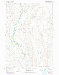
1964 Map of Mesa Spring
USGS Topo · Published 1980About this map
The Green River carves a winding path through this corner of Sublette County, defining a landscape shaped by both historic migration and intentional irrigation. Along the southern edge, the Emigrant Trail traces the historic route of western pioneers, while the upland plateau known as The Mesa dominates the eastern half of the quadrangle. The agricultural history of the basin is evident in the complex network of man-made waterways, including the Green River Supply Canal, Luman Ditch, and Harman Ditch, which redirect water from the river and Cottonwood Creek to the surrounding ranch lands. This 1964 survey, with revisions from 1978, illustrates a high-desert environment where water management is central to the land's utility, marked by scattered landmarks like Mesa Spring, Bloom Reservoir, and a remote Landing Strip.
Find a feature on this map
17 named features on this map. Tap any name to fly to it.
Don’t see what you’re looking for? This feature index may not catch every label — zoom into the map to look around manually.
Map Details
Editions of this 1964 Mesa Spring Map
2 editions found

Other maps of this area

1939 · Big Piney
USGS Topo · 1:125,000

1942 · Big Piney
USGS Topo · 1:125,000

1955 · Preston
USGS Topo · 1:250,000

1955 · Lander
USGS Topo · 1:250,000

1958 · Lander
USGS Topo · 1:250,000

1958 · Preston
USGS Topo · 1:250,000

1961 · Lander
USGS Topo · 1:250,000

1962 · Preston
USGS Topo · 1:250,000

1964 · Two Buttes Reservoir
USGS Topo · 1:24,000

1964 · Ross Butte
USGS Topo · 1:24,000