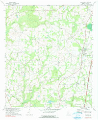
1971 Map of Pinehurst
USGS Topo · Published 1991About this map
Unadilla and Pinehurst anchor this rural landscape in Dooly County, where agricultural life is defined by a network of creeks and small crossroads settlements. The Southern and Seaboard Coast Line railroads cut through the terrain, establishing the transport corridors that supported the local cotton and farming economy during the early 1970s. The map reveals a high density of rural institutions, such as Red Hill Ch, Old Mt Zion Ch, and the Forest Chapel school, which served as community focal points for the surrounding farmsteads. Smaller hamlets like Findlay and Lilly appear alongside family-associated landmarks such as Forehand Cem and Mt Olive Cem. Drainage is managed by the winding courses of Turkey Creek, Little Creek, and Pennahatchee Creek, while more localized features like Oakbin Pond and Mount break the agricultural expanse. This survey preserves the spatial layout of Central Georgia's farmland before modern interstate development altered the character of these historic rail towns.
Find a feature on this map
27 named features on this map. Tap any name to fly to it.
Don’t see what you’re looking for? This feature index may not catch every label — zoom into the map to look around manually.
Map Details
Editions of this 1971 Pinehurst Map
2 editions found
Other maps of this area

1956 · Perry
USGS Topo · 1:62,500

1957 · Macon
USGS Topo · 1:250,000

1958 · Macon
USGS Topo · 1:250,000

1964 · Macon
USGS Topo · 1:250,000

1971 · Pineview NW
USGS Topo · 1:24,000

1971 · Pineview SW
USGS Topo · 1:24,000

1971 · Henderson
USGS Topo · 1:24,000

1971 · Pinehurst
USGS Topo · 1:24,000

1972 · Byromville
USGS Topo · 1:24,000

1972 · Drayton
USGS Topo · 1:24,000