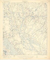
1919 Map of Pineland
USGS Topo · Published 1919About this map
Pineland and the surrounding Lowcountry of Jasper and Hampton Counties are defined by an intricate network of wetlands and small agricultural settlements at the end of the first World War. The landscape is dominated by the Coosawhatchie Swamp in the northeast and the expansive Calfpen Bay and Great Swamp to the south. This era shows the local economy tied closely to the land and the rails, with the Southern and Seaboard Air Line railroads providing the primary lifelines for communities like Furman, Stafford, and Scotia.
Find a feature on this map
57 named features on this map. Tap any name to fly to it.
Don’t see what you’re looking for? This feature index may not catch every label — zoom into the map to look around manually.
Map Details
Editions of this 1919 Pineland Map
3 editions found
Other maps of this area

1918 · Varnville
USGS Topo · 1:62,500

1918 · Yemassee
USGS Topo · 1:62,500

1919 · Pineland
USGS Topo · 1:62,500

1919 · Shirley
USGS Topo · 1:62,500

1919 · Cummings
USGS Topo · 1:62,500

1919 · Egypt
USGS Topo · 1:62,500

1920 · Hardeeville
USGS Topo · 1:62,500

1920 · Okatie
USGS Topo · 1:62,500

1920 · Peeples
USGS Topo · 1:62,500

1939 · Egypt
USGS Topo · 1:62,500