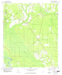
1978 Map of Pineland
USGS Topo · Published 1978About this map
The Savannah River defines the southwestern boundary of this 1978 survey, where the river's winding course is marked by engineered features like Cutoff No 7A and Sisters Cut. This corner of the Lowcountry is characterized by its agricultural settlements and extensive wetlands, notably the Black Swamp and Cypress Branch that permeate the landscape between Robertville and Garnett. The presence of numerous rural houses of worship, such as Solomon Temple, Antioch Ch, and St Marys Ch, reflects the long-standing community nodes of Jasper County.
Find a feature on this map
35 named features on this map. Tap any name to fly to it.
Don’t see what you’re looking for? This feature index may not catch every label — zoom into the map to look around manually.
Map Details
Editions of this 1978 Pineland Map
This is the sole edition of this map. No revisions or reprints were ever made.
Other maps of this area

1919 · Pineland
USGS Topo · 1:62,500

1919 · Shirley
USGS Topo · 1:62,500

1919 · Egypt
USGS Topo · 1:62,500

1920 · Hardeeville
USGS Topo · 1:62,500

1939 · Egypt
USGS Topo · 1:62,500

1943 · Pineland
USGS Topo · 1:62,500

1943 · Hardeeville
USGS Topo · 1:62,500

1943 · Egypt
USGS Topo · 1:62,500

1943 · Shirley
USGS Topo · 1:62,500

1947 · Savannah
USGS Topo · 1:250,000