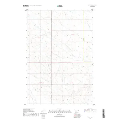
2020 Map of Piney Butte
USGS Topo · Published 2020About this map
Piney Butte rises above the open high plains of eastern Montana, marking a landscape defined by seasonal drainages and local thoroughfares. This 2020 topographical study captures the rangeland character of the region, where the county line between Carter Co and Fallon Co bisects the terrain. Navigational arteries like Pleyna Rd and Medicine Rocks RD provide the primary access through this sparsely populated area, following the natural contours of the land. The drainage network is particularly detailed, showing the headwaters and meandering paths of Spring Creek, S Fork Milk Cr, and E Fork O'Fallon Cr. These watercourses, along with Collins Cr, underscore the hydrological importance of even minor creeks in this semi-arid environment, serving as the historical lifeblood for livestock operations and early homesteading attempts.
Find a feature on this map
14 named features on this map. Tap any name to fly to it.
Don’t see what you’re looking for? This feature index may not catch every label — zoom into the map to look around manually.
Map Details
Editions of this 2020 Piney Butte Map
This is the sole edition of this map. No revisions or reprints were ever made.
Other maps of this area

1953 · Miles City
USGS Topo · 1:250,000

1954 · Ekalaka
USGS Topo · 1:250,000

1956 · Ekalaka
USGS Topo · 1:250,000

1957 · Miles City
USGS Topo · 1:250,000

1958 · Miles City
USGS Topo · 1:250,000

1958 · Ekalaka
USGS Topo · 1:250,000

1965 · Ekalaka
USGS Topo · 1:250,000

1979 · Ekalaka
USGS Topo · 1:24,000

1979 · Beaver Flats North
USGS Topo · 1:24,000
1980 · Terrell Creek
USGS Topo · 1:24,000