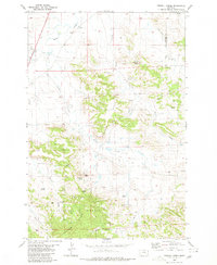
1980 Map of Terrell Creek
USGS Topo · Published 1980About this map
The Ekalaka Hills dominate the western landscape of this 1980 survey, marking a significant transition between the rolling drainage basins of Beaver Creek and the sheltered valleys within the Custer National Forest. This section of southeastern Montana is characterized by a high density of water sources, recorded through numerous family-named and topographic springs such as Flasted Spring, Sinrud Spring, and Johns Spring. These water points were critical for livestock and early ranching operations in a region where the network of ephemeral drainages like Terrell Creek and Collins Creek dictated movement and settlement. Distinctive geologic features like Chimney Rock and Red Hill provide essential vertical orientation across the ridgelines. Near the northern boundary, the presence of Limp and a Gravel Pit indicates localized infrastructure and material extraction, while the boundary between Carter County and Fallon County cuts across the northeastern corner of the map.
Find a feature on this map
24 named features on this map. Tap any name to fly to it.
Don’t see what you’re looking for? This feature index may not catch every label — zoom into the map to look around manually.
Map Details
Editions of this 1980 Terrell Creek Map
This is the sole edition of this map. No revisions or reprints were ever made.
Other maps of this area

1953 · Miles City
USGS Topo · 1:250,000

1954 · Ekalaka
USGS Topo · 1:250,000

1956 · Ekalaka
USGS Topo · 1:250,000

1957 · Miles City
USGS Topo · 1:250,000

1958 · Miles City
USGS Topo · 1:250,000

1958 · Ekalaka
USGS Topo · 1:250,000

1965 · Ekalaka
USGS Topo · 1:250,000

1979 · Ekalaka
USGS Topo · 1:24,000

1980 · Camp Needmore
USGS Topo · 1:24,000

1980 · Dutchmans Hill
USGS Topo · 1:24,000