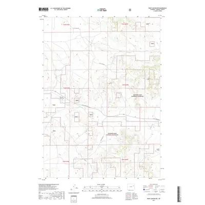
2017 Map of Piney Canyon NW
USGS Topo · Published 2017About this map
Thunder Basin National Grassland dominates this portion of Campbell County, where public lands are managed alongside ranching interests. The drainage system of Little Thunder Cr and its tributaries, including the N Prong Little Thunder Cr, carves a complex network through the landscape. High points like the H A Divide separate these drainages from the H A Cr basin to the north. Evidence of the region’s geological history and coal-rich strata appears in features such as Burning Coal Draw, a name that points to the subsurface fires common in the Powder River Basin. A network of arterial routes, including Little Thunder Rd and School Creek Rd, provides access to livestock tanks and seasonal water sources like H A Spring and M W Spring in this high-plains environment.
Find a feature on this map
20 named features on this map. Tap any name to fly to it.
Don’t see what you’re looking for? This feature index may not catch every label — zoom into the map to look around manually.
Map Details
Editions of this 2017 Piney Canyon NW Map
This is the sole edition of this map. No revisions or reprints were ever made.
Other maps of this area

1955 · Newcastle
USGS Topo · 1:250,000

1958 · Newcastle
USGS Topo · 1:250,000

1971 · Teckla
USGS Topo · 1:24,000

1971 · Piney Canyon NE
USGS Topo · 1:24,000

1971 · Open A Ranch
USGS Topo · 1:24,000

1971 · Reno Reservoir
USGS Topo · 1:24,000

1971 · Piney Canyon SW
USGS Topo · 1:24,000

1971 · Piney Canyon NW
USGS Topo · 1:24,000

1971 · Piney Canyon SE
USGS Topo · 1:24,000
1971 · Hilight
USGS Topo · 1:24,000