
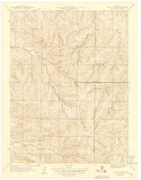
1942 Map of Piney Creek
USGS Topo · Published 1942About this map
The Colorado Front Range transitions into rolling drainage patterns on the eve of World War II, shown here at a high level of detail before the suburban expansion of Denver reached this intersection of counties. This 1942 edition represents a significant collaboration involving the State Highway Department and the City and County of Denver, with field work conducted during the late 1930s by the Work Projects Administration. The landscape is defined by the dendritic systems of Piney Creek and Coal Creek, which carve through the high plains terrain. Land use at this time is predominantly rural and agricultural, with the map recording the precise meeting point of Arapahoe, Douglas, and Elbert Counties. Water management and road planning are central themes, as evidenced by the sponsorship of the Denver Board of Water Commissioners and the intricate mapping of local gulches like Sulphur Gulch and Sampson Gulch.
Find a feature on this map
9 named features on this map. Tap any name to fly to it.
Don’t see what you’re looking for? This feature index may not catch every label — zoom into the map to look around manually.
Map Details
Editions of this 1942 Piney Creek Map
2 editions found
Other maps of this area

1890 · East Denver
USGS Topo · 1:125,000

1894 · Castle Rock
USGS Topo · 1:125,000

1913 · Castle Rock
USGS Topo · 1:125,000

1935 · East Denver Nos. 3 and 4
USGS Topo · 1:48,000

1939 · Coal Creek
USGS Topo · 1:24,000

1939 · Elizabeth
USGS Topo · 1:62,500

1940 · Piney Creek
USGS Topo · 1:24,000

1940 · Castle Rock
USGS Topo · 1:62,500

1941 · Fitzsimons
USGS Topo · 1:31,680

1942 · Parker
USGS Topo · 1:31,680