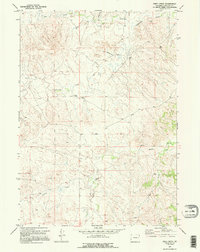
1970 Map of Piney Creek
USGS Topo · Published 1995About this map
Moore Ranch serves as a lone human landmark in this section of Converse County, where the high plains landscape is defined by a dendritic network of drainages. Ephemeral water sources and scattered infrastructure dominate the terrain, including Box Creek and Lightning Creek in the north, and Walker Creek further south. The map documents an area deeply tied to ranching and resource extraction, evidenced by several Flowing Wells and an isolated Oil Well. A remote Landing Strip near the center of the sheet indicates the vast distances involved in traversing this part of Wyoming during the late twentieth century. In the southern reaches, Willow Creek and Piney Creek cut through the topography, illustrating the essential relationship between water and land use in this semi-arid region.
Find a feature on this map
13 named features on this map. Tap any name to fly to it.
Don’t see what you’re looking for? This feature index may not catch every label — zoom into the map to look around manually.
Map Details
Editions of this 1970 Piney Creek Map
2 editions found
Other maps of this area

1954 · Torrington
USGS Topo · 1:250,000

1955 · Newcastle
USGS Topo · 1:250,000

1958 · Torrington
USGS Topo · 1:250,000

1958 · Newcastle
USGS Topo · 1:250,000

1970 · Bill 4 SE
USGS Topo · 1:24,000

1970 · Walker Creek School
USGS Topo · 1:24,000

1970 · Bill 4 NW
USGS Topo · 1:24,000

1970 · Lost Springs NW
USGS Topo · 1:24,000
1970 · Bill 4 SW
USGS Topo · 1:24,000
1970 · Simpson Draw NW
USGS Topo · 1:24,000