
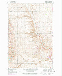
1952 Map of Pingree SW
USGS Topo · Published 1954About this map
Pipestem Creek winds through the heart of this Stutsman County landscape, which was mapped in the early 1950s as part of a Missouri River Basin development program. The terrain is defined by the high ground of Roundtop and the open expanses of Plainview, illustrating a rural landscape still organized by the traditional township and range system. This survey records the distribution of essential rural infrastructure, specifically the numbered schoolhouses that served the local farming community, including School No 1, School No 2, and School No 3. In the southern portion of the quadrangle, Hidden Lake and a Gravel Pit indicate localized drainage and early industrial activity, while a Gaging Station on the creek suggests the importance of water management and monitoring in this agricultural region during the mid-century era.
Find a feature on this map
11 named features on this map. Tap any name to fly to it.
Don’t see what you’re looking for? This feature index may not catch every label — zoom into the map to look around manually.
Map Details
Editions of this 1952 Pingree SW Map
2 editions found
Other maps of this area

1896 · Jamestown
USGS Topo · 1:125,000

1900 · Pingree
USGS Topo · 1:125,000

1900 · Pingree
USGS Topo · 1:62,500

1950 · Buchanan
USGS Topo · 1:24,000

1951 · Pingree
USGS Topo · 1:24,000

1951 · Eldridge NW
USGS Topo · 1:24,000

1952 · Buchanan
USGS Topo · 1:24,000

1952 · Eldridge
USGS Topo · 1:24,000

1952 · Jim Lake
USGS Topo · 1:24,000

1952 · New Rockford
USGS Topo · 1:250,000