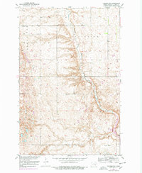
1952 Map of Pingree SW
USGS Topo · Published 1978About this map
Pipestem Creek meanders through this portion of Stutsman County, carving a distinct valley through the prairie landscapes of Plainview and the surrounding township lands. Compiled from 1948 aerial photography and 1950s ground surveys, the map documents a strictly rural township structure where civic life is anchored by a numbered system of local schools, including School No 1, School No 2, and School No 3. These small, distributed education centers were the heart of the early-to-mid-century farming community.
Find a feature on this map
13 named features on this map. Tap any name to fly to it.
Don’t see what you’re looking for? This feature index may not catch every label — zoom into the map to look around manually.
Map Details
Editions of this 1952 Pingree SW Map
2 editions found
Other maps of this area

1896 · Jamestown
USGS Topo · 1:125,000

1900 · Pingree
USGS Topo · 1:125,000

1900 · Pingree
USGS Topo · 1:62,500

1950 · Buchanan
USGS Topo · 1:24,000

1951 · Pingree
USGS Topo · 1:24,000

1951 · Eldridge NW
USGS Topo · 1:24,000

1952 · Buchanan
USGS Topo · 1:24,000

1952 · Eldridge
USGS Topo · 1:24,000

1952 · Jim Lake
USGS Topo · 1:24,000

1952 · Pingree SW
USGS Topo · 1:24,000