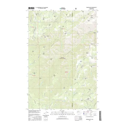
2017 Map of Pinkham Butte
USGS Topo · Published 2017About this map
Umatilla National Forest dominates this section of the Blue Mountains, where the border of Garfield and Asotin counties bisects a high-elevation landscape of deep drainages and narrow crests. The topography is defined by the headwaters of the Tucannon River and the various forks of Asotin Creek, which have carved out distinctive formations such as Pinkham Butte and the evocatively named Devils Tailbone Ridge. This 2017 data shows a land primarily managed for forestry and conservation, where access is provided by a network of National Forest Development Roads and rugged footpaths like the Pinkham Trail and the N Fork Asotin Creek Tr. Notable landmarks such as Jump Off Joe Point and Hard-to-get-to Ridge indicate the challenging nature of the terrain, while numerous water sources like Wick iup Spring and Frying Pan Spring suggest its importance for wildlife and livestock management in this part of Washington.
Find a feature on this map
131 named features on this map. Tap any name to fly to it.
Don’t see what you’re looking for? This feature index may not catch every label — zoom into the map to look around manually.
Map Details
Editions of this 2017 Pinkham Butte Map
This is the sole edition of this map. No revisions or reprints were ever made.
Other maps of this area

1937 · Pomeroy
USGS Topo · 1:96,000

1942 · Pomeroy
USGS Topo · 1:125,000

1943 · Peola
USGS Topo · 1:62,500

1943 · Saddle Butte
USGS Topo · 1:62,500

1946 · Saddle Butte
USGS Topo · 1:62,500

1946 · Peola
USGS Topo · 1:62,500

1955 · Pullman
USGS Topo · 1:250,000

1958 · Pullman
USGS Topo · 1:250,000

1967 · Rose Springs
USGS Topo · 1:24,000

1967 · Stentz Spring
USGS Topo · 1:24,000