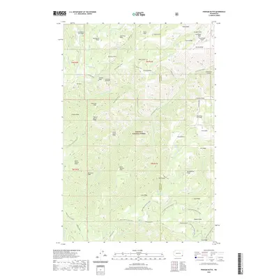
2020 Map of Pinkham Butte
USGS Topo · Published 2020About this map
Pinkham Butte stands as a central landmark in this high-altitude landscape within the Umatilla National Forest. The map documents a complex system of ridges and drainages that define the border between Garfield and Asotin counties. Distinctive topographic features like Jump Off Joe Point, Devils Tailbone Ridge, and the descriptive Hard-to-get-to Ridge indicate the challenging nature of the terrain. The network of seasonal water sources, including Bracken Springs and Frying Pan Spring, supported the early range and forest use in this area. Access is limited to primitive routes such as the Pinkham Trail and the evocatively named Hard-To-Get-To Trail, while more established thoroughfares like Cloverland Road and Lick Creek Road skirt the higher elevations. This map is particularly valuable for tracing historical resource management and high-country navigation patterns in the Blue Mountains region.
Find a feature on this map
81 named features on this map. Tap any name to fly to it.
Don’t see what you’re looking for? This feature index may not catch every label — zoom into the map to look around manually.
Map Details
Editions of this 2020 Pinkham Butte Map
This is the sole edition of this map. No revisions or reprints were ever made.
Other maps of this area

1937 · Pomeroy
USGS Topo · 1:96,000

1942 · Pomeroy
USGS Topo · 1:125,000

1943 · Peola
USGS Topo · 1:62,500

1943 · Saddle Butte
USGS Topo · 1:62,500

1946 · Saddle Butte
USGS Topo · 1:62,500

1946 · Peola
USGS Topo · 1:62,500

1955 · Pullman
USGS Topo · 1:250,000

1958 · Pullman
USGS Topo · 1:250,000

1967 · Rose Springs
USGS Topo · 1:24,000

1967 · Stentz Spring
USGS Topo · 1:24,000