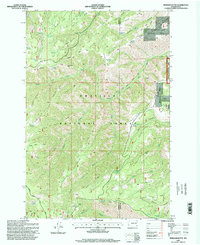
1995 Map of Pinkham Butte
USGS Topo · Published 1998About this map
Pinkham Butte stands as a central high point in this 1990s landscape, marking the transition between the Asotin Wildlife Area and the Umatilla National Forest. The map detail reveals an intricate network of high ridges and deep drainages, including the aptly named Hard to Get To Ridge and Tailbone Ridge. A tradition of seasonal water access is evident through numerous named springs, such as Fourth of July Spring and Wickiup Spring, which likely served as vital landmarks for forest travelers and early stockmen. The presence of the Government Trail and Pinkham Ridge Trail highlights the established path system used for regional forest management and early access. Notable land features like Smoothing Prairie and Jump off Joe Point provide unique geographic markers for those tracing historical land use and travel routes across the Garfield and Asotin county lines.
Find a feature on this map
59 named features on this map. Tap any name to fly to it.
Don’t see what you’re looking for? This feature index may not catch every label — zoom into the map to look around manually.
Map Details
Editions of this 1995 Pinkham Butte Map
This is the sole edition of this map. No revisions or reprints were ever made.
Other maps of this area

1937 · Pomeroy
USGS Topo · 1:96,000

1942 · Pomeroy
USGS Topo · 1:125,000

1943 · Peola
USGS Topo · 1:62,500

1943 · Saddle Butte
USGS Topo · 1:62,500

1946 · Saddle Butte
USGS Topo · 1:62,500

1946 · Peola
USGS Topo · 1:62,500

1955 · Pullman
USGS Topo · 1:250,000

1958 · Pullman
USGS Topo · 1:250,000

1967 · Rose Springs
USGS Topo · 1:24,000

1967 · Stentz Spring
USGS Topo · 1:24,000