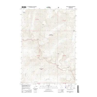
2015 Map of Pinnacle Mountain
USGS Topo · Published 2015About this map
Absaroka Range peaks dominate this high-altitude landscape on the boundary of Shoshone National Forest and Teton National Forest. The topography is defined by significant vertical relief, where summits like Pinnacle Mtn and Chaos Mtn tower over drainages such as Avalanche Cr and Eurie Cr. The map captures a wilderness environment devoid of permanent settlements or modern road infrastructure, relying instead on routes like the Mountain Creek Trail for navigation. Notable hydrologic features and alpine basins, including Flora Lake and Glacier Basin, illustrate the glaciated character of the terrain. The transition from high summits to more level ground is found at Eagle Creek Meadows and Fishhawk Meadows, providing rare flat openings within the dense forest and rock of the range. This survey provides a precise record of these undeveloped corridors and the various named creeks, including Howell Fork and Fishhawk Cr, that feed the region's larger watersheds.
Find a feature on this map
26 named features on this map. Tap any name to fly to it.
Don’t see what you’re looking for? This feature index may not catch every label — zoom into the map to look around manually.
Map Details
Editions of this 2015 Pinnacle Mountain Map
This is the sole edition of this map. No revisions or reprints were ever made.
Other maps of this area

1885 · Lake
USGS Topo · 1:125,000

1893 · Ishawooa
USGS Topo · 1:125,000

1895 · Ishawooa
USGS Topo · 1:125,000

1895 · Lake
USGS Topo · 1:125,000

1896 · Lake
USGS Topo · 1:125,000

1899 · Ishawooa
USGS Topo · 1:125,000

1901 · Lake
USGS Topo · 1:125,000

1906 · Lake
USGS Topo · 1:125,000

1911 · Lake
USGS Topo · 1:125,000

1955 · Ashton
USGS Topo · 1:250,000