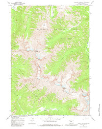
1970 Map of Pinnacle Mountain
USGS Topo · Published 1983About this map
Pinnacle Mountain serves as the central landmark for this high-elevation landscape, where the boundaries of the Shoshone National Forest and Teton National Forest meet. This 1970 survey records a transition point in the Absaroka Range, documenting the vast Washakie Wilderness and Teton Wilderness through a network of drainage systems. Major watercourses like Eagle Creek and Howell Creek carve through the terrain, fed by high-altitude features such as Flora Lake and Glacier Basin. The mapping of numerous unnamed falls and the singular Falls label on Cloudburst Creek indicates the steep gradients typical of this region. Human presence is indicated strictly by the Pack Trail system, including the route following Fishhawk Creek, highlighting the area's designation as a primitive backcountry environment preserved at the start of the 1970s.
Find a feature on this map
22 named features on this map. Tap any name to fly to it.
Don’t see what you’re looking for? This feature index may not catch every label — zoom into the map to look around manually.
Map Details
Editions of this 1970 Pinnacle Mountain Map
This is the sole edition of this map. No revisions or reprints were ever made.
Other maps of this area

1885 · Lake
USGS Topo · 1:125,000

1893 · Ishawooa
USGS Topo · 1:125,000

1895 · Ishawooa
USGS Topo · 1:125,000

1895 · Lake
USGS Topo · 1:125,000

1896 · Lake
USGS Topo · 1:125,000

1899 · Ishawooa
USGS Topo · 1:125,000

1901 · Lake
USGS Topo · 1:125,000

1906 · Lake
USGS Topo · 1:125,000

1911 · Lake
USGS Topo · 1:125,000

1955 · Ashton
USGS Topo · 1:250,000