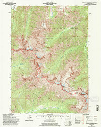
1991 Map of Pinnacle Mountain
USGS Topo · Published 1997About this map
Pinnacle Mountain towers over a landscape defined by the intersection of high-altitude drainages and federally protected wildlands in the Absaroka Range. Revised by the U.S. Forest Service in the early 1990s, this area serves as a critical boundary where the Washakie Wilderness meets the Teton Wilderness, marking the division between the Shoshone and Teton National Forests. The hydrological network is dense, featuring the headwaters of Eagle Creek, Fishhawk Creek, and Avalanche Creek, which carve through deep drainages toward lower elevations.
Find a feature on this map
22 named features on this map. Tap any name to fly to it.
Don’t see what you’re looking for? This feature index may not catch every label — zoom into the map to look around manually.
Map Details
Editions of this 1991 Pinnacle Mountain Map
This is the sole edition of this map. No revisions or reprints were ever made.
Other maps of this area

1885 · Lake
USGS Topo · 1:125,000

1893 · Ishawooa
USGS Topo · 1:125,000

1895 · Ishawooa
USGS Topo · 1:125,000

1895 · Lake
USGS Topo · 1:125,000

1896 · Lake
USGS Topo · 1:125,000

1899 · Ishawooa
USGS Topo · 1:125,000

1901 · Lake
USGS Topo · 1:125,000

1906 · Lake
USGS Topo · 1:125,000

1911 · Lake
USGS Topo · 1:125,000

1955 · Ashton
USGS Topo · 1:250,000