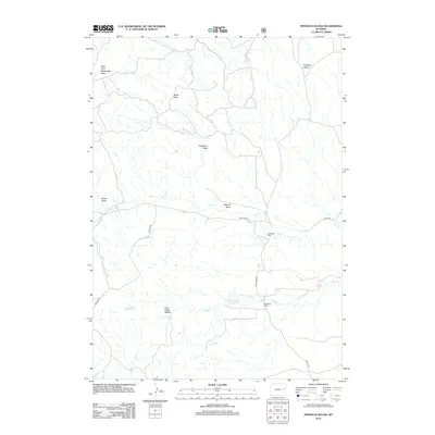
2012 Map of Pinnacle Rocks
USGS Topo · Published 2012About this map
Pinnacle Rocks rise above a landscape defined by an intricate network of drainages and ranching outposts in this Wyoming terrain. The map documents the persistent agricultural footprint of the region, anchored by the Alexander Ranch and Middleton Ranch. Water management is central to life here, evidenced by the Middle Number 1 Reservoir and the numerous draws such as West Fork Rattlesnake Draw and Nachtman Draw that funnel seasonal runoff toward Cow Cr and Wagonhound Cr. Significant elevation changes are marked by the Miller Hills and the prominent Cow Creek Buttes to the south. The road system, including Cow Creek Rd and Burke Rd, follows the natural contours of the land, providing access between isolated homesteads and grazing lands. This survey provides a clear view of the ranching infrastructure and topographic landmarks that characterize this portion of Converse County.
Find a feature on this map
18 named features on this map. Tap any name to fly to it.
Don’t see what you’re looking for? This feature index may not catch every label — zoom into the map to look around manually.
Map Details
Editions of this 2012 Pinnacle Rocks Map
This is the sole edition of this map. No revisions or reprints were ever made.
Other maps of this area

1955 · Newcastle
USGS Topo · 1:250,000

1958 · Newcastle
USGS Topo · 1:250,000

1970 · Bill 4 NE
USGS Topo · 1:24,000

1971 · Fiddleback Ranch
USGS Topo · 1:24,000

1971 · Esau Spring
USGS Topo · 1:24,000

1979 · Bill
USGS Topo · 1:100,000

1981 · Calf Draw
USGS Topo · 1:24,000
1981 · Wagonhound Creek
USGS Topo · 1:24,000

1981 · Mercer Draw
USGS Topo · 1:24,000

1981 · Pinnacle Rocks
USGS Topo · 1:24,000