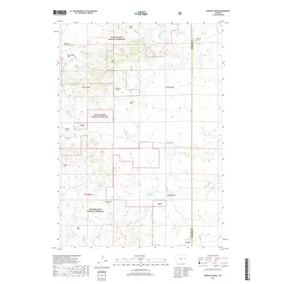
2017 Map of Pinnacle Rocks
USGS Topo · Published 2017About this map
Thunder Basin National Grassland dominates this section of the Wyoming high plains, where the landscape is defined by an intricate network of ephemeral watercourses and subtle topographic rises. The drainage pattern is particularly dense, characterized by named features such as West Fork Rattlesnake Draw and Nachtman Draw which carve through the arid terrain. The Miller Hills and the namesake Pinnacle Rocks provide vertical relief against the wide-open prairie, while the Middle Cr Reservoir serves as a vital water catchment for the region. The map also delineates the jurisdictional boundary between Converse and Niobrara counties, showing the rural infrastructure of Cow Creek Rd and K-Field Rd that connects isolated ranchlands. This document captures the intersection of public land management and the traditional cattle-grazing geography of the American West.
Find a feature on this map
26 named features on this map. Tap any name to fly to it.
Don’t see what you’re looking for? This feature index may not catch every label — zoom into the map to look around manually.
Map Details
Editions of this 2017 Pinnacle Rocks Map
This is the sole edition of this map. No revisions or reprints were ever made.
Other maps of this area

1955 · Newcastle
USGS Topo · 1:250,000

1958 · Newcastle
USGS Topo · 1:250,000

1970 · Bill 4 NE
USGS Topo · 1:24,000

1971 · Fiddleback Ranch
USGS Topo · 1:24,000

1971 · Esau Spring
USGS Topo · 1:24,000

1979 · Bill
USGS Topo · 1:100,000

1981 · Calf Draw
USGS Topo · 1:24,000
1981 · Wagonhound Creek
USGS Topo · 1:24,000

1981 · Mercer Draw
USGS Topo · 1:24,000

1981 · Pinnacle Rocks
USGS Topo · 1:24,000