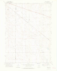
1973 Map of Pinneo
USGS Topo · Published 1976About this map
Pinneo and the surrounding high plains of Washington Co are defined by the industrial and transport infrastructure that supports this portion of Eastern Colorado. The Burlington Northern railroad cuts a diagonal path across the landscape, linking the small settlement at Midway with larger regional networks. This 1970s survey captures a transition in local land use, where traditional agricultural features like the Old Black Tank Windmill exist alongside an active energy sector. The southeastern portion of the map is dominated by the West Xenia Oil Field, marked by numerous Oil Wells and Drill Holes. Water management is prominent through the presence of an Aqueduct and the intermittent drainage of Camp Creek, illustrating the critical role of resource extraction and irrigation in this semi-arid environment.
Find a feature on this map
16 named features on this map. Tap any name to fly to it.
Don’t see what you’re looking for? This feature index may not catch every label — zoom into the map to look around manually.
Map Details
Editions of this 1973 Pinneo Map
3 editions found
Other maps of this area

1951 · Merino SW
USGS Topo · 1:24,000

1951 · Brush East
USGS Topo · 1:24,000

1951 · Merino SE
USGS Topo · 1:24,000

1954 · Sterling
USGS Topo · 1:250,000

1958 · Sterling
USGS Topo · 1:250,000

1965 · Gary
USGS Topo · 1:24,000

1965 · Miller Ranch
USGS Topo · 1:24,000

1971 · Brush East
USGS Topo · 1:24,000

1973 · Rago
USGS Topo · 1:24,000

1973 · Fremont Butte
USGS Topo · 1:24,000