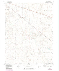
1973 Map of Pinneo
USGS Topo · Published 1984About this map
Pinneo serves as a central landmark in this high-plains landscape, where the agricultural and energy sectors of northeastern Colorado intersect. Situated along the Burlington Northern railroad, the small settlement of Pinneo and the nearby Midway reflect the rail-dependent transport patterns of the era. The industrial character of the region is further defined by the West Xenia Oil Field and numerous scattered drill holes and wells, indicating the importance of petroleum extraction to the local economy. An Aqueduct cuts across the terrain, illustrating the infrastructure required for water management in this semi-arid environment. The boundary between Morgan and Washington Counties runs vertically through the survey, providing a clear reference point for genealogists and local historians tracing property lines and jurisdictional history in the early 1970s.
Find a feature on this map
14 named features on this map. Tap any name to fly to it.
Don’t see what you’re looking for? This feature index may not catch every label — zoom into the map to look around manually.
Map Details
Editions of this 1973 Pinneo Map
3 editions found
Other maps of this area

1951 · Merino SW
USGS Topo · 1:24,000

1951 · Brush East
USGS Topo · 1:24,000

1951 · Merino SE
USGS Topo · 1:24,000

1954 · Sterling
USGS Topo · 1:250,000

1958 · Sterling
USGS Topo · 1:250,000

1965 · Gary
USGS Topo · 1:24,000

1965 · Miller Ranch
USGS Topo · 1:24,000

1971 · Brush East
USGS Topo · 1:24,000

1973 · Rago
USGS Topo · 1:24,000

1973 · Fremont Butte
USGS Topo · 1:24,000