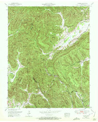
1952 Map of Pioneer
USGS Topo · Published 1972About this map
The mountain terrain of the Cumberland Mountain and Chimney Mountain range defines this 1952 field revision of Campbell and Scott counties. The Southern railroad winds through the central valley, connecting the settlements of Pioneer and Stanfill along the course of the Elk Fork. This drainage system, which includes Little Elk Creek and Stinking Creek, historically dictated the placement of small rural communities and local institutions. Scattered throughout the hollows and along the ridges are numerous community landmarks, including the Lick Fork School, Emmanuel Church, and family-named burial grounds like the Baird Cemetery and Lay Cemetery. The landscape is a complex network of gaps and knobs, such as Braden Gap, Blockade Gap, and Potato Knob, which shaped the early wagon roads and paths through these highland passes. Farther south, the map details the area around Royal Blue and the Royal Blue School, illustrating the localized social centers of the mid-century Cumberland Plateau.
Find a feature on this map
79 named features on this map. Tap any name to fly to it.
Don’t see what you’re looking for? This feature index may not catch every label — zoom into the map to look around manually.
Map Details
Editions of this 1952 Pioneer Map
4 editions found
Other maps of this area

1890 · Williamsburg
USGS Topo · 1:125,000

1893 · Briceville
USGS Topo · 1:125,000

1894 · Williamsburg
USGS Topo · 1:125,000

1895 · Briceville
USGS Topo · 1:125,000

1896 · Briceville
USGS Topo · 1:125,000

1936 · Ivydell
USGS Topo · 1:24,000

1936 · Block
USGS Topo · 1:24,000

1936 · Jacksboro
USGS Topo · 1:24,000

1936 · Pioneer
USGS Topo · 1:24,000

1936 · La Follette
USGS Topo · 1:48,000