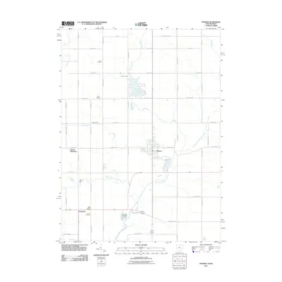
2011 Map of Pioneer
USGS Topo · Published 2011About this map
The village of Pioneer serves as the central hub of this Williams County landscape, situated where the Clear Fork joins the East Branch Saint Joseph River. The surrounding rural territory is defined by a dense network of family and community history, evidenced by a high concentration of burial grounds including Alfred Cemetery, Amboy Cemetery, Drake Cemetery, and Pease Cemetery. The drainage of Silver Creek and Laird Creek dictates the local topography, while the southern reaches feature smaller named locales such as Jim Town and the Greyhound station area.
Find a feature on this map
51 named features on this map. Tap any name to fly to it.
Don’t see what you’re looking for? This feature index may not catch every label — zoom into the map to look around manually.
Map Details
Editions of this 2011 Pioneer Map
This is the sole edition of this map. No revisions or reprints were ever made.
Other maps of this area

1913 · Alvordton
USGS Topo · 1:62,500

1914 · Pioneer
USGS Topo · 1:62,500

1944 · Pioneer
USGS Topo · 1:62,500

1944 · Alvordton
USGS Topo · 1:62,500

1953 · Fort Wayne
USGS Topo · 1:250,000

1956 · Fort Wayne
USGS Topo · 1:250,000

1959 · Reading
USGS Topo · 1:24,000

1959 · Frontier
USGS Topo · 1:24,000
1961 · Pioneer
USGS Topo · 1:24,000
1961 · West Unity
USGS Topo · 1:24,000