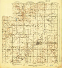
1914 Map of Pioneer
USGS Topo · Published 1941About this map
The St Joseph River meanders through the heart of Williams County, Ohio, during this early 20th-century survey. The landscape is defined by its agricultural grid, dotted with numbered rural schoolhouses and small crossroads such as Bridgewater Center and Union Corners. The industrial activity of the era is anchored by Montpelier, where the Wabash RR forms a significant junction, and the village of Pioneer, served by the Toledo and Western RR.
Find a feature on this map
70 named features on this map. Tap any name to fly to it.
Don’t see what you’re looking for? This feature index may not catch every label — zoom into the map to look around manually.
Map Details
Editions of this 1914 Pioneer Map
2 editions found
Other maps of this area

1907 · Defiance
USGS Topo · 1:62,500

1909 · Defiance
USGS Topo · 1:62,500

1913 · Alvordton
USGS Topo · 1:62,500

1914 · Pioneer
USGS Topo · 1:62,500

1914 · Bryan
USGS Topo · 1:62,500

1939 · Clear Lake
USGS Topo · 1:24,000

1940 · Metz
USGS Topo · 1:24,000

1940 · Clear Lake
USGS Topo · 1:24,000

1943 · Bryan
USGS Topo · 1:62,500

1944 · Pioneer
USGS Topo · 1:62,500