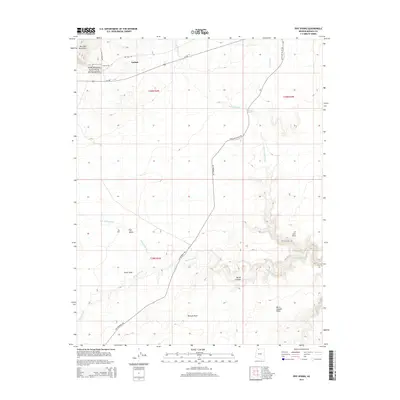
2014 Map of Pipe Spring
USGS Topo · Published 2014About this map
Pipe Spring National Monument serves as the focal point of this arid landscape, preserving a vital oasis in the high desert of the Arizona Strip. The settlement of Kaibab and the nearby community of Moccasin are situated along the base of the Moccasin Mountains, where water sources like Pipe Spring historically supported habitation in an otherwise parched environment. The map details a complex network of seasonal drainages, including Twomile Wash and Pipe Valley Wash, which carve through the plateau toward southern landforms such as Bulrush Point and Burnt Canyon Point. Significant routes like Az-389 and Mt Trumbull Rd provide modern access through this remote territory, while landmarks like Scotts Hole and Twomile Seep indicate the critical importance of isolated water points for livestock and travelers in this section of Mohave County.
Find a feature on this map
24 named features on this map. Tap any name to fly to it.
Don’t see what you’re looking for? This feature index may not catch every label — zoom into the map to look around manually.
Map Details
Editions of this 2014 Pipe Spring Map
This is the sole edition of this map. No revisions or reprints were ever made.
Other maps of this area

1886 · Kaibab
USGS Topo · 1:250,000

1953 · Grand Canyon
USGS Topo · 1:250,000

1954 · Fredonia NW
USGS Topo · 1:24,000

1954 · Short Creek SE
USGS Topo · 1:24,000

1954 · Fredonia SW
USGS Topo · 1:24,000

1954 · Fredonia NE
USGS Topo · 1:24,000

1954 · Fredonia
USGS Topo · 1:62,500

1954 · Short Creek
USGS Topo · 1:62,500

1954 · Heaton Knolls
USGS Topo · 1:62,500
1956 · Short Creek NE
USGS Topo · 1:24,000