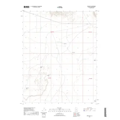
2018 Map of Pipe Valley
USGS Topo · Published 2018About this map
Pipe Valley Wash courses through this high desert plateau, carving a seasonal drainage system across the Arizona landscape. This Mohave County terrain is defined by its distinct geological formations and local landmarks, most notably the high vantage points of Yellowstone Mesa and the aptly named Elephants Foot. The map illustrates a region of remote range land, where the topography shifts from the broad basin of Pipe Valley to the shadowed depths of Bulrush Canyon and Le Fevre Canyon. Transport is largely restricted to unpaved routes, with CO Hwy 241 providing the primary thoroughfare across the northern sections. Topographic details reveal the complex drainage patterns feeding into the wash, surrounding notable rises like Moonshine Ridge and Indian Knoll, which served as critical navigation points for those traveling through this section of the Kaibab region.
Find a feature on this map
13 named features on this map. Tap any name to fly to it.
Don’t see what you’re looking for? This feature index may not catch every label — zoom into the map to look around manually.
Map Details
Editions of this 2018 Pipe Valley Map
This is the sole edition of this map. No revisions or reprints were ever made.
Other maps of this area

1886 · Kaibab
USGS Topo · 1:250,000

1953 · Grand Canyon
USGS Topo · 1:250,000

1954 · Heaton Knolls NW
USGS Topo · 1:24,000
1954 · Short Creek SW
USGS Topo · 1:24,000

1954 · Fredonia NW
USGS Topo · 1:24,000

1954 · Short Creek SE
USGS Topo · 1:24,000
1954 · Short Creek NW
USGS Topo · 1:24,000

1954 · Fredonia SW
USGS Topo · 1:24,000

1954 · Fredonia
USGS Topo · 1:62,500

1954 · Short Creek
USGS Topo · 1:62,500