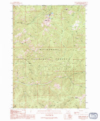
1991 Map of Piquett Mountain
USGS Topo · Published 1994About this map
Bitterroot National Forest encompasses this high-elevation terrain in Ravalli County, defined by a network of drainage basins and prominent summits. The geography is anchored by Piquett Mountain and the high point of Wiles Peak, with alpine waters collected in Shelf Lake and Slate Lake. The landscape is etched by numerous watercourses including Overwhich Creek, Gentile Creek, and Antler Creek.
Find a feature on this map
27 named features on this map. Tap any name to fly to it.
Don’t see what you’re looking for? This feature index may not catch every label — zoom into the map to look around manually.
Map Details
Editions of this 1991 Piquett Mountain Map
2 editions found
Other maps of this area

1956 · Elk City
USGS Topo · 1:250,000

1960 · Elk City
USGS Topo · 1:250,000

1960 · Painted Rocks Lake
USGS Topo · 1:62,500

1960 · Piquett Mountain
USGS Topo · 1:62,500

1964 · Boulder Peak
USGS Topo · 1:24,000

1964 · Piquett Creek
USGS Topo · 1:24,000

1965 · Medicine Hot Springs
USGS Topo · 1:24,000
1991 · Piquett Mountain
USGS Topo · 1:24,000
1991 · Henderson Ridge
USGS Topo · 1:24,000
1991 · Painted Rocks Lake
USGS Topo · 1:24,000