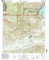
1995 Map of Piru
USGS Topo · Published 2000About this map
Piru serves as the central hub of this mid-1990s landscape, where the confluence of Piru Creek and the Santa Clara River dictates the local geography. The map captures a sophisticated water management system, anchored by the Santa Felicia Dam and the Piru Lake reservoir, alongside a dedicated Percobation Basin. To the south and east, the historical legacy of the region is visible through the expansive boundaries of the Temascal Grant and San Francisco Grant, which contrast with the industrial presence of oil wells and oil tanks concentrated near Hopper Canyon.
Find a feature on this map
50 named features on this map. Tap any name to fly to it.
Don’t see what you’re looking for? This feature index may not catch every label — zoom into the map to look around manually.
Map Details
Editions of this 1995 Piru Map
This is the sole edition of this map. No revisions or reprints were ever made.
Other maps of this area

1900 · Piru
USGS Topo · 1:62,500

1903 · Tejon
USGS Topo · 1:125,000

1903 · Camulos
USGS Topo · 1:125,000

1903 · Santa Susana
USGS Topo · 1:62,500

1921 · Piru
USGS Topo · 1:62,500

1931 · Whitaker Peak
USGS Topo · 1:24,000

1931 · Santa Felicia Canyon
USGS Topo · 1:24,000

1935 · Santa Felicia Canyon
USGS Topo · 1:24,000

1935 · Whitaker Peak
USGS Topo · 1:24,000

1941 · Piru
USGS Topo · 1:62,500