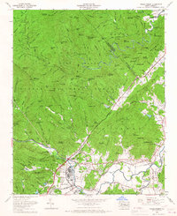
1965 Map of Pisgah Forest
USGS Topo · Published 1967About this map
The French Broad River and Davidson River converge in this mid-1960s survey of Transylvania County, where industrial sites and mountain coves meet. The community of Pisgah Forest serves as a focal point near the Southern Railway tracks, showing the proximity of manufacturing infrastructure to the protected wilderness of the Pisgah National Forest. This era shows the developed corridor along State Highway 280 connecting Penrose and Blantyre, while the northern half of the map is dominated by the ridges and gaps of the Pisgah Game Preserve. High-altitude features like the Pink Beds and the Blue Ridge Parkway illustrate the transition from the valley floor to the high mountains. Local history is anchored by numerous small landmarks, including the Davidson River Cemetery, Turkey Creek Cemetery, and several rural sanctuaries such as Oak Grove Church and English Chapel.
Find a feature on this map
88 named features on this map. Tap any name to fly to it.
Don’t see what you’re looking for? This feature index may not catch every label — zoom into the map to look around manually.
Map Details
Editions of this 1965 Pisgah Forest Map
4 editions found
Other maps of this area

1905 · Pisgah
USGS Topo · 1:125,000

1906 · Pisgah
USGS Topo · 1:125,000

1935 · Cruso
USGS Topo · 1:24,000

1935 · Brevard
USGS Topo · 1:24,000

1935 · Standingstone Mtn.
USGS Topo · 1:24,000

1935 · Horse Shoe
USGS Topo · 1:24,000

1935 · Rosman
USGS Topo · 1:24,000

1935 · Shining Rock
USGS Topo · 1:24,000

1935 · Pisgah Forest
USGS Topo · 1:24,000

1936 · Skyland
USGS Topo · 1:24,000