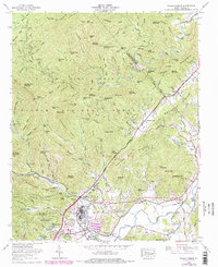
1965 Map of Pisgah Forest
USGS Topo · Published 1978About this map
Brevard and the adjacent industrial hub of Pisgah Forest anchor this mid-1960s landscape where the French Broad River valley meets the rising peaks of the Blue Ridge. The presence of the Southern Railway and the Ecusta facility highlights the mid-century industrial footprint, while the Transylvania Community Hospital marks the growing infrastructure of the county seat. Beyond the valley floor, the map details the rugged ascent into the Pisgah National Forest and Pisgah Game Lands, reaching toward high points like Buttermilk Mountain and Laurel Mountain. Rural life is preserved through numerous family and community landmarks, including Penrose Sch and several country sanctuaries such as Enon Ch and Blantyre Ch. The topography is etched with numerous gaps and knobs, like Wagon Road Gap and Sutton Knob, illustrating the traditional travel routes through the mountains before modern highway development fully bypassed these steep gaps.
Find a feature on this map
185 named features on this map. Tap any name to fly to it.
Don’t see what you’re looking for? This feature index may not catch every label — zoom into the map to look around manually.
Map Details
Editions of this 1965 Pisgah Forest Map
4 editions found
Other maps of this area

1905 · Pisgah
USGS Topo · 1:125,000

1906 · Pisgah
USGS Topo · 1:125,000

1935 · Cruso
USGS Topo · 1:24,000

1935 · Brevard
USGS Topo · 1:24,000

1935 · Standingstone Mtn.
USGS Topo · 1:24,000

1935 · Horse Shoe
USGS Topo · 1:24,000

1935 · Rosman
USGS Topo · 1:24,000

1935 · Shining Rock
USGS Topo · 1:24,000

1935 · Pisgah Forest
USGS Topo · 1:24,000

1936 · Skyland
USGS Topo · 1:24,000